HREOC Website: Isma - Listen: National consultations on eliminating prejudice against Arab and Muslim Australias
Consultations
Homepage
|| Fact Sheet
FACT SHEET:
Muslim & Arab Australians in Western Australia
1. Muslim Australians
- Total number of
Muslims in Australia: 281,578 - Total number of
Muslims in Western Australia: 19,456 - Proportion of
the Australian population who are Muslim: 1.5% - Proportion of
the Queensland population who are Muslim: 1.1%
*Source: Australian Bureau of Statistics (ABS), 2001 Census.
Figure 1:
Australian Muslim population by state and territory
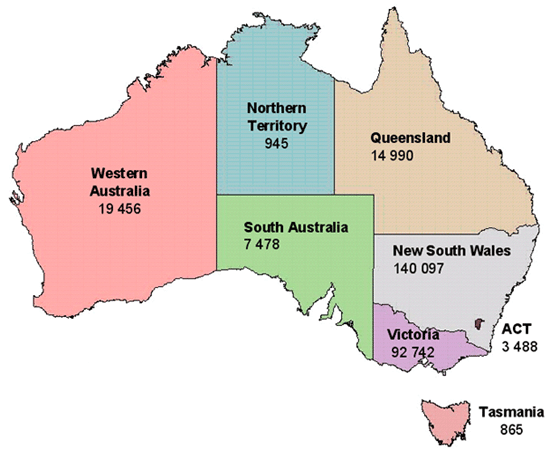
Source:
ABS, 2001 Census. Basic Community Snapshots and Profiles.
Click here for text only version.
Table 1: Geographic
Distribution of Muslims in Australia, 2001
|
State/territory
|
Proportion
of all Australian Muslims |
Proportion
of total state or territory population |
| New South Wales |
50% | 2.2% |
| Victoria | 33% | 2.0% |
| Western Australia |
7% | 1.1% |
| Queensland | 5% | 0.4% |
| South Australia |
3% | 0.5% |
| Australian Capital Territory |
1% | 1.1% |
| Northern Territory |
0.3% | 0.5% |
| Tasmania | 0.3% | 0.2% |
Total |
100% |
1.5% |
Source:
ABS, 2001 Census.
Table 2: Distribution
of Australian Muslims by major statistical local areas in the Perth statistical
division, 2001
| Statistical local area |
Number |
| Stirling (C) - Central |
2766 |
| Gosnells (C) | 2206 |
| Canning (C) | 1902 |
| Swan (C) | 1480 |
| Wanneroo (C) - South |
994 |
| Bayswater (C) | 916 |
| Victoria Park (T) |
698 |
| Joondalup (C) - South |
655 |
| Melville (C) | 652 |
| South Perth (C) |
639 |
| Belmont (C) | 599 |
| Cockburn (C) | 495 |
| Joondalup (C) - North |
467 |
| Stirling (C) - Coastal |
338 |
| Vincent (T) | 266 |
| Wanneroo (C) - North-West |
263 |
| Armadale (C) | 248 |
| Subiaco (C) | 233 |
| Rockingham (C) | 222 |
| Perth (C) - Remainder |
217 |
| Kalamunda (S) | 190 |
| Stirling (C) - South-Eastern |
153 |
| Fremantle (C) - Remainder |
126 |
| Cambridge (T) | 111 |
| Nedlands (C) | 98 |
| Wanneroo (C) - North-East |
92 |
| Bassendean (T) | 88 |
| Mosman Park (T) |
79 |
| Kwinana (T) | 77 |
| Claremont (T) | 46 |
| Mundaring (S) | 40 |
| Fremantle (C) - Inner |
26 |
| Serpentine-Jarrahdale (S) |
26 |
| Perth (C) - Inner |
20 |
| East Fremantle (T) |
13 |
| Cottesloe (T) | 10 |
| Peppermint Grove (S) |
0 |
| Total for Perth SD |
17,451 |
*Source: ABS 2001
Census, Unpublished Data.
2. Arab &
Middle-Eastern Australians
- Total number
of Australians born in the Middle East or North Africa in Australia:
213,940
(1.1% of the national population) - Total number Australians
born in the Middle East or North Africa in Western Australia: 9,506
(0.5% of the WA state population)
*Source: Australian
Bureau of Statistics (ABS), 2001 Census.
Definitions
Defining who is an
‘Arab’ or exactly which countries lie within the Middle East
is a complex matter.
The Australian Bureau
of Statistics (ABS) defines the Middle East as: Bahrain,
Gaza Strip and West Bank (Palestine), Iran, Iraq, Israel, Jordan, Kuwait,
Lebanon, Oman, Qatar, Saudi Arabia, Syria, Turkey, United Arab Emirates,
Yemen. North Africa is defined as: Algeria, Egypt, Libya,
Morocco, Sudan, Tunisia and the Western Sahara. ‘Arab’
includes: Algerian, Egyptian, Iraqi, Jordanian, Kuwaiti, Lebanese, Libyan,
Moroccan, Palestinian, Saudi Arabian, Syrian, Tunisian.
This summary uses
ABS definitions and highlights specific countries of origin for a significant
number of Australians. These countries are: Lebanon, Egypt, Turkey, Iraq,
Iran, Syria and Israel. Other Middle Eastern, North African and Arab countries
with much smaller representation in Australian are grouped into two categories:
- ‘Other Middle
East’ (which includes Bahrain, Jordan, Kuwait, Oman, Palestine,
Qatar, Saudi Arabia, United Arab Emirates and Yemen) - ‘Other North
Africa’ (which includes Algeria, Libya, Morocco, Sudan, Tunisia,
Mauritania, Djibouti and Western Sahara)
Table 3: Main countries of
birth of Australians of Middle Eastern & North African origin, 2001
|
Country
of birth |
Number
|
| Lebanon | 71 349 |
| Egypt | 33 432 |
| Turkey | 29 821 |
| Iraq | 24 832 |
| Iran | 18 789 |
| Syria | 6 710 |
| Israel | 6 574 |
| Other Middle East |
13 212 |
| Other North Africa |
8 918 |
| Other not further defined |
303 |
Total |
213
|
Figure 2:
State & territory distribution of Australians born in the Middle East
& North Africa, 2001
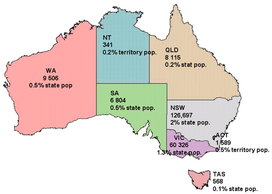
Source: ABS, 2001
Census. Basic Community Profiles and Snapshots.
Click here for text only version.
Table 4: Australians born
in the Middle East or North Africa in major statistical areas of Perth,
2001
|
Statistical
Local Area |
Egypt
|
Iran
|
Iraq
|
Lebanon
|
Syria
|
Turkey
|
Other
Middle East |
Other
North Africa |
Total
|
| Stirling (C) - Central |
187 | 243 | 409 | 64 | 22 | 54 | 93 | 151 | 1223 |
| Canning (C) |
51 | 117 | 57 | 90 | 19 | 188 | 196 | 49 | 767 |
| Gosnells (C) |
62 | 37 | 169 | 112 | 14 | 80 | 132 | 70 | 676 |
| Melville (C) |
133 | 183 | 33 | 70 | 0 | 16 | 103 | 41 | 579 |
| Swan (C) |
62 | 98 | 181 | 49 | 8 | 14 | 64 | 18 | 494 |
| Joondalup (C) - North |
96 | 167 | 12 | 23 | 6 | 27 | 82 | 14 | 427 |
| Joondalup (C) - South |
146 | 72 | 9 | 48 | 6 | 22 | 82 | 41 | 426 |
| Bayswater (C) |
56 | 115 | 82 | 21 | 10 | 19 | 64 | 54 | 421 |
| Wanneroo (C) - South |
43 | 54 | 93 | 43 | 3 | 9 | 24 | 41 | 310 |
| South Perth (C) |
45 | 104 | 19 | 29 | 10 | 13 | 49 | 10 | 279 |
| Belmont (C) |
27 | 25 | 37 | 60 | 13 | 57 | 40 | 18 | 277 |
| Cockburn (C) |
69 | 47 | 3 | 46 | 14 | 26 | 25 | 16 | 246 |
| Stirling (C) - Coastal |
60 | 50 | 14 | 7 | 7 | 19 | 48 | 20 | 225 |
| Victoria Park (T) |
11 | 27 | 23 | 25 | 5 | 35 | 22 | 9 | 157 |
| Vincent (T) |
35 | 22 | 16 | 4 | 0 | 11 | 23 | 31 | 142 |
| Cambridge (T) |
40 | 27 | 6 | 3 | 3 | 9 | 24 | 8 | 120 |
| Wanneroo (C) - North-West |
62 | 4 | 6 | 3 | 8 | 7 | 21 | 0 | 111 |
| Armadale (C) |
27 | 3 | 9 | 18 | 3 | 10 | 23 | 18 | 111 |
| Kalamunda (S) |
20 | 5 | 3 | 21 | 0 | 8 | 20 | 12 | 89 |
| Rockingham (C) |
27 | 7 | 0 | 16 | 5 | 11 | 14 | 9 | 89 |
| Nedlands (C) |
17 | 31 | 3 | 5 | 3 | 3 | 25 | 0 | 87 |
| Subiaco (C) |
15 | 36 | 6 | 3 | 0 | 9 | 14 | 3 | 86 |
| Stirling (C) - South-Eastern |
10 | 13 | 12 | 4 | 3 | 10 | 13 | 8 | 73 |
| Fremantle (C) - Remainder |
31 | 17 | 5 | 3 | 0 | 4 | 4 | 6 | 70 |
| Perth (C) - Remainder |
10 | 19 | 12 | 5 | 0 | 8 | 9 | 4 | 67 |
| Mosman Park (T) |
8 | 16 | 11 | 3 | 3 | 3 | 13 | 4 | 61 |
| Wanneroo (C) - North-East |
10 | 5 | 4 | 5 | 3 | 0 | 14 | 18 | 59 |
| Bassendean (T) |
14 | 18 | 5 | 3 | 0 | 0 | 4 | 8 | 52 |
| Mundaring (S) |
13 | 8 | 3 | 5 | 0 | 0 | 7 | 14 | 50 |
| Claremont (T) |
9 | 14 | 0 | 4 | 0 | 3 | 9 | 9 | 48 |
| East Fremantle (T) |
12 | 7 | 0 | 0 | 0 | 0 | 3 | 6 | 28 |
| Kwinana (T) |
4 | 13 | 0 | 0 | 0 | 3 | 4 | 3 | 27 |
| Cottesloe (T) |
3 | 7 | 0 | 0 | 0 | 0 | 5 | 0 | 15 |
| Perth (C) - Inner |
3 | 4 | 0 | 3 | 0 | 3 | 0 | 0 | 13 |
| Serpentine-Jarrahdale (S) |
0 | 5 | 0 | 0 | 0 | 0 | 0 | 6 | 11 |
| Peppermint Grove (S) |
3 | 4 | 0 | 0 | 0 | 0 | 0 | 0 | 7 |
| Fremantle (C) - Inner |
0 | 0 | 0 | 0 | 0 | 4 | 3 | 0 | 7 |
| Total for Perth SD |
1234 | 1381 | 833 | 731 | 146 | 631 | 1183 | 568 | 6707 |
*Source: ABS, 2001
Census, Unpublished data.
Race Discrimination
Unit, Human Rights and Equal Opportunity Commission, July 2003. ABS data
used with permission from the Australian Bureau of Statistics.